
By Ericka Hegeman, GIS Research Scientist at UW EarthLab
Catalyzing Innovation in Stormwater Solutions
The iconic rain of the Puget Sound region creates problems when it hits the streets and other impervious surfaces that characterize this highly developed urban landscape. The resulting stormwater runoff carries toxic contaminants into nearby waterways, degrades habitat and water quality, and causes flooding, touching nearly all facets of the coupled human and natural system.
In 2019, the Water 100 Project kicked off an effort to identify, assess, fund, and implement the 100 most substantive solutions for improving system conditions, benefiting humans and nature in ways that extend well beyond stormwater pollution. Researchers at the University of Washington and The Nature Conservancy are taking this work a step further, exploring innovative tools to galvanize high-impact stormwater solutions and address prioritization challenges including project placement, equitable impacts, and limited data availability.
This article is the second installment in a three-part series describing the methodologies utilized by three UW research teams and their thoughts on how these tools might benefit future conservation work.
Multi-Objective Prioritization Methodology
Pollutant inputs from stormwater have negative impacts on salmon habitat and human health, particularly in frontline communities that face greater impacts of climate change and environmental degradation. While the sources of stormwater pollution are clear, the solutions can be costly and need to be placed intentionally to target specific co-benefits for people and wildlife, such as improved water quality, mental health, and climate mitigation. The University of Washington and The Nature Conservancy research team was challenged with identifying how to make siting decisions for green stormwater infrastructure projects such as rain gardens or tree planting with the goal of maximizing co-benefits in the Puget Sound region.

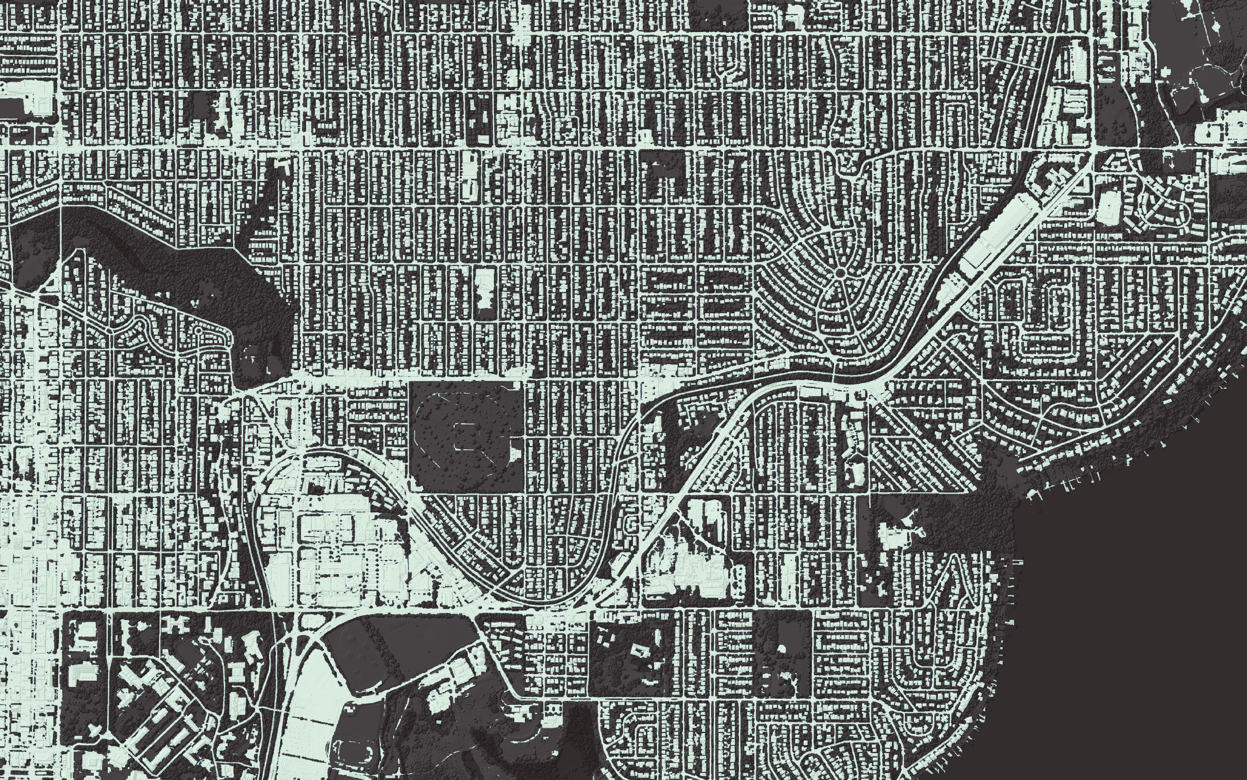
The study area (green polygons) was located within the Puget Sound watershed (blue line) and included 868 census tracts that contained complete data.
What research tool was utilized or developed?
To aid decision-making and stormwater planning, the team used a multi-objective prioritization methodology to determine how different stormwater solutions benefit people and salmon. While multi-objective prioritization can include two or more co-benefits, this study was confined to two benefits. This approach relied on publicly available datasets to create a risk assessment framework for human health (i.e., risk = sensitivity x exposure) to identify high-priority locations (at census tract scale) that would have the greatest benefit to frontline communities.
Sensitivity was based on a socio-economic index that mirrors the Washington State Health Disparities Index and combined ranked values of six socio-economic variables across the study area: low educational attainment, linguistic isolation, poverty, unemployment, housing burden, and transportation expense.
Exposure used a pollution index that included three metals of concern: zinc, copper, and lead.
Salmon health was based on the total length of salmon-bearing streams within each census tract.
The potential co-benefits to people and salmon were evaluated against the availability to implement green stormwater infrastructure, as identified by three different opportunity metrics: impervious surface (such as concrete), road length, and bridge count. The quantity of each metric was used as a proxy for the potential availability of different types of stormwater infrastructure (e.g., more bridges located within a given census tract indicates more opportunities to implement green bridge design).
The research compared four different prioritization methodologies: two dual-objective methods which used unique combinations of both salmon and human health and two single-objective methods that used either salmon health or human health. Each methodology included two process steps: prioritization, then ranking. But the dual-objective methodologies differed from the single-objective methodologies in that the second step included a two-part ranking using both salmon and human health. Preliminary results show similar rankings from the dual-objective methodologies as the single-objective methodologies, though at a somewhat less efficient rate. This indicates that benefits to both salmon and frontline community health can be achieved by building both goals into the prioritization. When planners focus on a single objective, it can limit their ability to provide co-benefits when deciding where to place green stormwater infrastructure.

Example schematic of the dual-objective prioritization using salmon health in the first step and both human health and salmon health in the second step.
How could the tool be applied? How might it benefit conservation work elsewhere?
The multi-objective prioritization methodology presented in a forthcoming peer-reviewed journal article provides a systematic decision-making framework that can be used to plan the placement of green stormwater infrastructure. Prioritizations can be tailored to different geographic regions, co-benefits, and types of infrastructure. These methods can be replicated with publicly available data and modified with project-specific datasets to provide government agencies and nonprofits with guidance regarding where to start thinking about implementing green infrastructure solutions. For instance, these methods can be refined so that large municipalities interested in prioritizing the placement of specific types of green infrastructure to maximize benefits for humans and salmon can work towards identifying these locations. With the methodologies developed for this research, practitioners can identify the best placement for various types of green stormwater infrastructure that maximize co-benefits to aquatic ecosystems important for Coho and Chinook salmon as well as frontline communities. By placing stormwater infrastructure in these areas, practitioners can expand their scope of impact and ensure solutions are more equitable by addressing human health disparities in addition to improving ecological health.
Where can additional information about the tool be found?
The recently updated Washington State Health Disparities Map is an excellent resource for a wide variety of socio-economic metrics in Washington State. Information regarding salmon-bearing streams in Washington State is available via the Washington State Department of Fish and Wildlife’s Salmonscape map. The pollution index data used for this work closely mirrors the pollutant loading data available on TNC’s Stormwater Heatmap website.
Connect with Ericka Hegeman for further information about this work.

Featured image: Spring downpour on deck in Bellevue. © Heather Van Steenburgh/TNC


